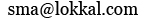
What we do know is the Felipe II had incurred considerable expense in his war with England and n building his mausoleum, Escorial. From the king’s perspective, the revenue from his colonies might contain the resources and tribute in order to reverse his monetary problems. Those resources are clearly present in the map.
In the 16th century it took time for the team to map and interview the inhabitants of the watershed. The obvious fold marks in the original map speak of the conditions under which the investigators and cartographers had to work. It was folded in half three times in order to keep it safe in a little space, possibly in saddle bags. These folded maps in the 19th century in the US were actually called saddle maps. As in the Luis and Clark Expedition they probably made preliminary sketches and kept details in journals. Either these documents did not survive or have yet to be discovered. If they ever are discovered there will be quite an adrenaline rush, at least for us antiquarians. Nevertheless, the pictorial aspects of the map told Felipe a great deal about the watershed and its possible exploitation.
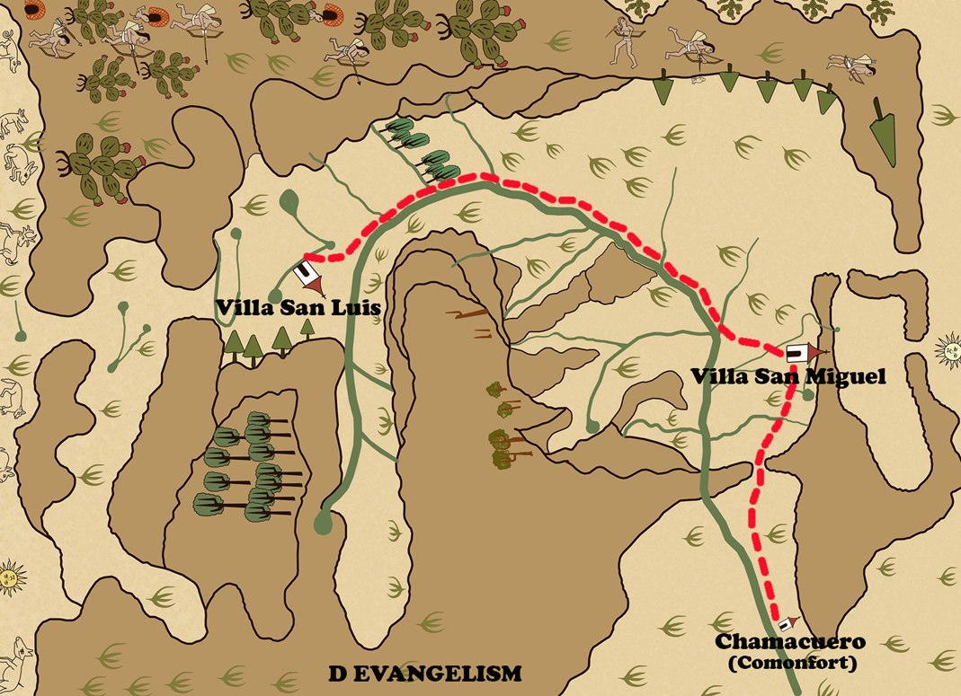
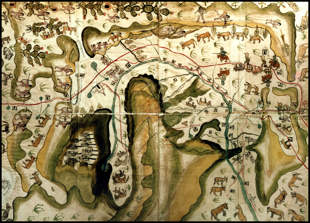
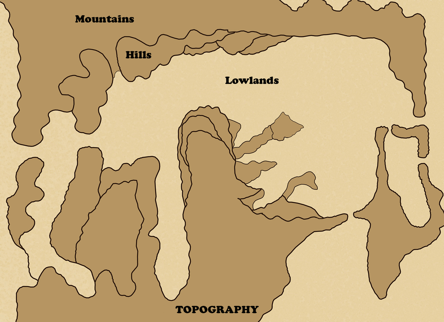
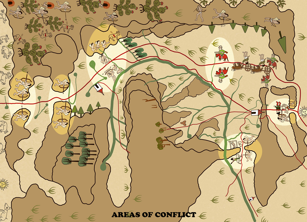
I have made and post here several cartoons, separating different aspect of the map that might help explain better my verbal description.
The physical aspects of the watershed include mountains, hills and valleys. The Laja River, called the San Miguel River on the map; with its tributaries and location of natural springs, form an important part of the exploitable hydrological information. The native biology of the watershed includes forested mountains and hills, as well as, expansive grasslands in the middle and lower elevations. Numbers of nopal or prickly pear are located in the watershed on the northwest corner of the map. It is worthy to note that the native fauna is almost entirely absent within the limits of the watershed. The artist has clearly indicated by 1580 these animals, like deer, javelin, rabbits, etc. were, with one exception, located near or outside the western boundaries of the watershed.
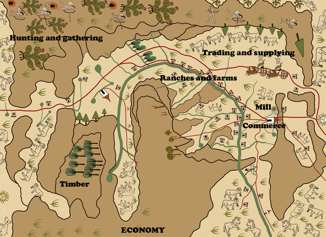
The map also gave Felipe II indications of how his colonists and the indigenous peoples were exploiting the watershed by 1580. In the lower elevations of the watershed there are livestock ranches in the grasslands and farms along the banks of the river. In the ridge just to the northeast of San Miguel the map pictures a hydraulic grain mill. Remnants of the old mill can be seen today in the canyon of Charco del Ingenio. Important commerce traveling along the Camino Real Tierra Adentro is being escorted by Spanish Conquistadores.
Meanwhile, the indigenous peoples and their thatched settlements are isolated in the very northwest corner of the map. The women of the villages are peering out to the south from their thatched dwellings where their men, armed with bows and arrows, are hunting Spanish cattle and the Spanish themselves. Ambushes along the Royal Road have been strategically situated near rivers and mountain passes were the intruders were most vulnerable. The conflicts ensuing from Spain’s occupation of the watershed are immediately apparent. The painted map shows the decapitated heads of two friars near a ravine. A short distance to the west, on a ridge above the pass from Chamacuero (Comonfort), an Indian has been hanged. To the east, near the rising sun is another hanging. The Indian was apparently hanged, for the killing of a Spaniard and his horse painted directly to the west of the mountain pass, near the present day community of Puerto de Nieto.
The mountains with their Oak and Pine forests, the potential minerals, the massive grasslands, abundant water sources, and even the inhabitants, were all exploitable. With this map, Felipe II was able to make informed decisions, and that must have made him very happy. This information makes me happy because we are able to compare the watershed over 470 years ago with what it is like today.
**************
Donald Patterson, scholar and author, also worked as a consultant in environment, Universidad A. de Querétaro, Faculty of Natural Sciences, "watershed management" in the following projects:
2012-2013: Strategic Plan for the Sub-basin, Upper Rio Laja. With the participation of UAQ, FAI and funded by the Gonzalo Rio Arronte Foundation. Creation of a database for the sub-basin. We managed to capture more than 40,000 documents.
2009-2012: Ecological Management Plan Program (POET). With the participation of UAQ, the State Institute of Ecology, SEMARNAT, economic sectors of the municipality of San Miguel de Allende, social organizations, Municipal Directorate of Environment and Ecology and funded by the H.A. 2009 - 2012. The program was passed by the municipal council and the state government and published in the Official Gazette.
**************
*****
Please contribute to Lokkal,
SMA's online collective:
 ***
***
Discover Lokkal:
Watch the two-minute video below.
Then, just below that, scroll down SMA's Community Wall.
Mission

Visit SMA's Social Network
Contact / Contactar